Since the survey was conducted on agricultural fields in rural areas, there was a high chance of facing connectivity issues. Therefore it became important to have an app which works without internet. SurveyCTO helped to address this issue by providing offline survey features.

SurveyCTO provides flexibility in updating the questionnaire mid-survey–for instance, when enumerators find more crops beyond their given list, or when we need to modify the enumerator list.


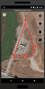
COLLECT GPS DATA
Easily measure farm plots
Geolocation data collection capabilities on your device can work online or offline to make agricultural data collection fast, simple, and accurate.

POWERFUL SECURITY
Protect sensitive data
Security options like end-to-end encryption, user roles with permissions, and SSO support keep your data safe.

INTEGRATED DATASETS
Simplified list management
Conveniently manage lists of respondents and program beneficiaries with our flexible server datasets, or track subjects over time in our case management datasets.